Thursday 3 October 2013

Marquee Races Weekend - 24 and 25/08/2013

A great weekend of racing in Yorkshire and the Lakes...

August Bank Holiday weekend is the peak season for the "Marquee" Fell Races, short and sharp races associated with village shows or sports and often with good cash prizes (not that that concerns me, but it makes sure a lot of elite guys come out and tow us mortals round at a reasonable clip).

Mercia planned a weekend away to the two most classic of these very traditional events: Burnsall Feast and Grasmere Sports, both of which are well covered in "Feet in the Clouds".

Burnsall Classic Fell Race

1.5 miles, 899'

21:01; 57/152

Grasmere Senior Guides Race

1.6 miles, 886'

20:35; 93/195

More details and pics to follow...

Monday 19 August 2013

Training - 12 to 18/08/2013

Wednesday 14/08/2013 - morning
Quickish Cliffe Run
0:21, 250' (2.3 miles)

Grabbed a fairly quick run around the Cliffe just before dawn - beautiful morning with trails of mist in the wide Severn and Dee valleys either side of me and trees poking out above the sea of grey. Lovely sunrise too.

Thursday 15/08/2013 - evening
Pre-Committee Wrekin Blast
0:34, 900' (2.8 miles)

Squeezed a climbing session out on the Wrekin in between work and Mercia committee. Up the scree gully to Halfway House, down Beeches to the bottom, then up the BMX track and the main path to the summit. Down via my network of tracks on the east face to pick up the main track at the hairpin below Halfway House. Pushed fairly hard tonight, good session, climbing ok. Descended quickly but fairly easy.

Sunday 18/08/2013 - morning
Nav Coaching
0:45, 450' (1.1 miles) - walk
1:05, 1,600' (4.9 miles) - run

Coached basic nav skills to a group of 12 this morning. Walk - trip to bottom of Hundred Steps, then Townbrook reservoir and return over hill in Rectory Wood. Run - relays leg 1, followed this pretty much exactly with Kate W, Steve T and Steve B. Plenty of stops to practise map and compass work. Nice run with some quicker sections. legs a little tired on Yearlet.

Sunday 18/08/2013 - afternoon
Skyline Reccie
2:25, 2,050' (10.4 miles) - slow run

Cleared up coaching session and went straight over to the other side of Stretton to run a reccie of the second half of the Skyline with Zoe. All fine until Gogbatch, climbing quite well, then suddenly desperately tired and quite low. Dehydrated too. Found our way back to All Stretton via Plush Hill and a bit of the Batch Bash route only to discover the pub was shut. Walked back to Church Stretton along the road. Finally the blind blisters on my heels from the Hundred have moved forward a bit with one blowing up and tearing (the skin underneath is nice an hard though so it should be ok). I thought I'd done the job at Stiperstones, but it's taken another month and the use of an unusual pair of socks!

Summary
5:10, 5,250' (21.5 miles)
Another rather easy week, need to do some proper session planning. Two short relatively quick sessions, but were they hard enough? And was the running on Sunday easy enough? Evidently not in the conditions. Mileage a little low, but a reasonable amount of climbing. Would like to keep climbing >5,000' per week as I have found I go quite well off that. Distance could creep up a bit.

Thursday 8 August 2013

Training - 22 to 28/07/2013

Not much done this week because Zoe arrived back from a month in Africa on Tuesday and I took a few days off to enjoy a bit of time with her. We did however manage to take part in the Gritstone Tryal on Sunday 28th as a first run back for Zoe and a nice steady long run with a nav challenge thrown in for me.

Friday 26/07/2013 - evening
MAF Pace Jog
0:31, 300' (3.0 miles)

Three easy miles around Nesscliffe. A loop round the very outside of the school field is 400m, useful for future reference...

Sunday 28/07/2013 - morning
Gritstone Tryal
2:37, 1,650' (11.0 miles)

The Gritstone Tryal is a navigation event run by Ian Ankers of Staffordshire Moorlands AC. The format is simple - you're given a map with numbered checkpoints marked on it when you arrive and have up to an hour to decide how to get round the checkpoints (in order). The event then commences with a mass start. Zoe and I thought we had plenty of time to sort the route out, but in reality I was still marking my map up with ten minutes to go.

Event map - my mark-up in blue
After a little footwear crisis (correct decision - trail shoes are nice and comfy and fine even on rough bits of the Peak when it hasn't rained much for weeks), we were on the start line and then away. We all took the same (obvious) line to CP1 with a few queues for the dibbers and a pair of kissing gates, then crossed the A53 and split.

We selected the better line for leg 2 but ruined it with some poor execution, losing the indistinct ROW and being drawn too far round the valley. We came out on the minor road instead of a slightly more major one, I forgot the road width coding on the map and we turned the wrong way to compound the initial error. I thus ended up doing the tough bit of my intended line (first half) and the tough bit of the other line (second half). Never mind.

Leg 3 was predominately across fields with three shallow valleys to cross. The first sunken lane we used was atrocious, boggy and rough under 3' high reeds. We then had to duck under trees for the next 200m and climb a fence where there was no sign of a stile (near Well Springs Farm). The uphill section to Colshaw was fine, although we use the field adjacent to the sunken lane as it was a lot easier going. We had to be careful across fields near Colshaw not to get drawn off our line by the sight of many other competitors over to our right who'd chosen a hiller but possibly slightly shorter line crossing the valleys a little further downstream. Our next valley crossing was gained by some desperate descending through another scrubby wood with little sign of the ROW on the ground. We found the footbrige OK though and the climb up the next field wasn't too bad. There was no ROW signing after Brand Top and nothing on the ground - a descent on a grassy spur gave onto 250m of hideous bog with neck high reeds: fortunately I found a way through on flattened sections to the final stream crossing. I did manage to get my head up on the way down and had noticed a nice newly mown hayfield roughly where the right hand option was for the final climb to CP3, so we cut across to that leaving some other competitors labouring on much rougher ground and reached CP3 ahead of a few folk.

The leg to CP4 was obvious and very runnable and we put in a good effort here past the HSE fire testing grounds at Turncliff. There were several burnt out tube carriages over to our left at one point. We also passed Stanley Moor Reservoir. This large rectangular structure was built over underlying material honeycombed by solution holes and caverns and was decommissioned about ten years ago under the supervision of one of my colleagues. The works removed a large wedge of the dam on the east side and used the material to partly fill the impoundment, creating a series of wildlfe pools. CP4 was another manned checkpoint - Ian had driven out here from the event centre to do the honours.

I'd looked carefully at the leg to CP5 and come up with an option which was about 3 km, mostly on trails. There was a road option which was nearly 4 km but it meant running 2 km along the busy A53 and a less obvious approach to CP5 itself across rough ground so I'd decided there was no advantage in it. Zoe hadn't trained at all while she was in Uganda and she suffered up the climb to the A54, feeling sick and with jelly legs. We slowed right down and I told her not to worry, she'd feel better in a bit. She forced herself to run most of the section over Axe Edge Moor, but we lost about 5 places on this leg. The checkpoint itself was easily found and we had a welcome cup of water there.

I'd decided to take a direct line from CP5 to CP6 across the moor but after 200m I could tell Zoe was really struggling so we cut back to the fence all our competitors were following and went down that until we were level with a small knoll on the right which was obvious on the map. As the others went straight on on a more circuitous route, Zoe and I took a bearing (which conveniently coincided with Shining Tor, clearly visible to the west) and we walked across rough moorland nearly 1 km and dropped in 50m north of the checkpoint exactly as planned. This meant we'd overtooken all of the guys who'd passed us on the way from CP4, so I was pretty pleased with the leg.

We had a cunning plan for leg 7 too. The more obvious routes used rights of way across farmland between Blackclough and Knotbury, but they looked navigationally complex, so I'd come up with a line to the west, using a byway which would lead up to the road and thence the checkpoint. As a further refinement we could cut a corner where the track zigzagged down a steep hill and save another 200m. The plan worked perfectly and by CP7 we'd shaken off everyone following except Jackie Keasley from Helsby RC.

Leg 8 was straightforward up over Wolf Edge and down to a checkpoint on the last wall before Flash vilalage. Even so we lost half our lead ovr Jackie as Zoe and I both missed a stile on our right near the top of the climb and had to backtrack 20m.

We clipped at CP8 and just had 400m of road running in to the finish, where we found to our surprise that Zoe had won a bottle of wine for finishing 2nd lady! Although the running was pretty comfortable for me I did feel myself getting into it around CP5 and feeling fairly strong.

A good morning out, great views, a good nav challenge and a decent long run for us both - thank you to Ian and all your helpers.

I've attached a scan of the event map showing our plan, and the actual route taken is on Strava:


Summary
3:08, 1,950' (14.0 miles)
A much easier week. Nice to spend some time relaxing and to have the practise of navigating under (some) pressure in the Tryal. I need to try to get some more consistency in my training for the next three weeks though...

Friday 2 August 2013

Training - 15 to 21/07/2013

Monday 15/07/2013 - evening
MAF Pace Climbing Reps
0:53, 750' (3.5 miles)

Got out with the dog on a slightly less hot evening. I'm trying to work on my climbing after the issues I had in Norway controlling my HR on the ascents - and I realise I hadn't done much structured fell work since well before the hundred, so it's probably been three months. Tonight I stayed local, jogging over to the bottom of the steepest sustained climb at Nesscliffe, the one I call "School Gully". I tried to climb well within myself, powerhiking and breathing through my nose every two paces, slowing down if I started to get out of breath or felt my HR creeping up. At the end of each climb (about 3.5 minutes) I jogged down the easy steady descent (about 5.5 minutes) ready for the next climb. Four reps tonight, but that was because the dog was getting hot and tired :-) Felt good, got to try to do this session or something similar more often. Probably didn't gain full fat burning effect though because I was starrving when I got in and had a Twix just before I went out to run...

Tuesday 16/07/2013 - evening
Rest / X Train
Resisted the temptation to run. Mowed the lawn and walked the dog instead. Stiperstones race tomorrow.

Wednesday 17/07/2013 - evening
Stiperstones Fell Race
0:37 plus warm-up, 1,250' (3.7 miles)

I hadn't done a short fell race for too long! They are fun, even if you're not properly trained for them and you are tired. Primarily this was a good opportunity for some intense training, and I decided beforehand to work as hard as I could for as long as I could without risking damaging myself. I should have started a little quicker on the wider section as I got badly held up on the first climb and descent but by the second climb I was pretty much in the right place in the field. At the top of the steep section of the second climb, the character of the route changes completely, from singletrack to an ATV road, which continues to climb at about 1:10 for nearly a mile. I struggled up here and did a deal with myself to keep running. I did manage to run the route out, only Paul and Val passed me up this section and they are both considerably quicker than me on the flat. I held position on the steep technical descent but by the road my heels were burning hot (it was a very warm dry night) and I eased off for fear that the damaged skin from the ultras would give out altogether and I'd have a recurrence of the foot problems I had after Three Peaks in 2011. In the end they just about held together and a dunk in the stream at the end saved them! I lost about 7/8 places on the final run-in but wasn't bothered, and given the lack of any specific prep I was quite happy with 37:09 and 34th place of 79. My previous race was not a good one (in 2011, after no sleep whatsoever the night before, I'd run 43:41.

Saturday 20/07/2013 - afternoon
Very Easy Run on Snowdon
1:51 (moving time), 2,100' (7.6 miles)

My friend Mel got her first England cap today, in the Snowdon International Mountain Race. I went out to support, setting off up the hill 20 minutes before the start of the race after a natter with some of my many friends who were running. I jogged up to about the 1,250' point and waited for the lead runners. I stood chatting and taking photos as most of the field came up. Mel looked great and very happy in her shiny new England kit! Then walked gently on up with some of the back markers - it would have been rude to run past them... At 2,200' I met Al Tye, and stood with him for a while as the leaders and the first third of the field came back down. I then headed off in the extremely strong sun and heat, picking a nice line down into the valley under Cloggy cliffs, then diagonally up steep rough ground to pick up the Snowdon Ranger path above the Cwm Brwynog - Cwm Clogwyn col. From there a still over the fence leads to a sketchy but lovely traversing path under Moel Cynghorion. I cut across the Afon Arddu valley and climbed up to Hebron Station to pick up the main Llanberis path as the tail enders were finishing the race, and stopped at the ice cream barn for a 99 and a Fanta on the way back to the event field. Paul Jones of Mercia had won the V40 open race and Mel had done great finishing between Pippa Maddams and Helen Berry as second counter for the England ladies. A meal in the Corn Mill in Llangollen on the way home rounded off an excellent day.

Sunday 21/07/2013 - lunchtime
Burway Hill Climb (Coaching Session)
0:42 (moving time), 650' (3.6 miles)

Did our first Mercia summer coaching session this morning. Mostly on uphill technique. Afterwards 19 of the 23 students, plus Tom and myself, went for a run up Burway Hill putting some of the technique into practise. Mostly back marked and coached.

Training - 08 to 14/07/2013

Monday 08/07/2013 - evening
Caer Caradoc
0:54, 850' (3.6 miles)
Stopped at Church Stretton on the way back from Gatwick after the Norway trip. Yomped up Caradoc past Three Fingers Rock with Bailey. Skirted around the rocks a bit then down fundamentally the same way.

Wednesday 10/07/2013 - evening
Wrekin
0:55, 1,150' (3.8 miles)
Bits of the Wrecker and some new trails, trying to link up recent discoveries and avoid the main path. Some of this was at an easy pace, but I pushed on in one or two places, particularly the top half of the Goaty path. Feeling ok considering, some tightness at bottom of hamstrings and slight soreness in right ankle after Hornindal.

Thursday 11/07/2013 - evening
Sports massage
Went to see the ever-brilliant Dianne. Good release of my back between the shoulder blades, probably from wearing the running sack all weekend (inc.l as had baggage for flights). Worked quite hard / deep on the shin muscles (tibialis anterior). Need to keep working on the flexibility stuff I think - I'm considering a one-off physio appointment to get an assessment and some kind of training / stretching plan. Nice two mile walk along the canal towpath with the dog afterwards.

Friday 12/07/2013
Nesscliffe
1:07, 600' (5.0 miles)
Quite warm very gentle jog around the Cliffe, Hopton Hill and Nesscliffe Wood with Em. The emphasis was very much on the social aspect tonight, so I had a nice easy run. Felt ok after yesterday's massage: thankfully no adverse reaction in my shins! Di always seems to get it just right :-)

Sunday 14/07/2013 
Longmynd Longish Run 
2:47, 3,050' (12.6 miles) 
Started at 9:30 am which was way too late on one of the hottest days of the year. I was going to go round the Longmynd Valleys route, but realised as I reached the top of Jonathan's Hollow that, with many of the streams almost empty, water could be at a premium today. A change of plan was to drop down Ashes and if there was not drinkable water in the stream to go all the way down to the campsite, then cross Yearlet / Ashlet and do half of the Cardingmill Canter route to finish off. There was water in the stream in the hollow, so I went straight up Yearlet on an experimental line, right up the vague ridge between the west and south faces which is a pretty direct line to the top. It eases after a while and on a cooler day the top half of the climb would be runnable. Coming off Yearlet I bumped into a Newport/Telford AC trio - it was nice to see them after a while. Went round onto Ashlet and then down the Green Path and the ramp to the cafe in Cardingmill. Filled up the bottle and grabbed a salt sachet, which I ate half of on the start of the next climb. I tried the path which goes round the back of the bungalow and takes Bodbury on pretty much direct. It's steep, unrelenting and compsed mostly of slippy gravel. I had to stop a couple of times and really felt I was running out of steam. I managed to drag my weary carcass up to Haddon Hill, then did the Canter descent and jogged round the pipeline to New Pool. It was heaving with sunbathers and swimmers. After a quick swim / cool down I jogged down the valley to finish off. Some good climbing, but I felt pretty weak today. Maybe it was just the heat? 

Summary
5:43, 5,650' (25 miles) and a massage.

A start in getting back to training properly and specifically for fell running. After the problems at Hornindal on Saturday I managed to get some decent climbing done. I'm also thinking it might be an idea at this phase in my cycle to get a bit of physio support to sort out a few niggles and weaknesses: a slight left side groin strain I've had for months, the under-activated glutes and psoas muscles, sore/overused shin muscles and the stiffness in my lower back which can lead to tightness down my glutes, hams, calves and Achilles. That's quite a shopping list!

Hornindal Rundt - 06/07/2013

Looking fairly composed five minutes before the start!
The advance publicity for this race offered a "38 km fjelløp. 2 900 høgdemeter!" and a "75 km ultrafjelløp. 5 600 høgdemeter". I don't think a lot of translation is required but a fjelløp can be roughly equated to a fell race. I found the event on the UTMB qualifying events list (not so much because I wanted to gain UTMB points but because it's a great way to find events), and entered early this year. The main event of the "season" was the LDWA 100 and this was six weeks later, so I figured there would probably be enough recovery time to get it sufficiently together for a big fell ultra. After all I'd done Brecon 40 and the Tour de Hellvellyn, both at 40 miles and about 10,000' feet of clibing, not to mention last year's CCC at 56 miles and 19,000' so 45 miles and 18,500' should be do-able, right?

I organised to travel over on the Thursday to give Friday to settle in / recover and reccie a small section of the route, then race on Saturday, recover on Sunday and travel home on Monday.

It all went fairly straightforwardly and I arrived in Grodås (the main village in the valley of Hornindal) as planned on Thursday night, and spent Friday doing a gentle reccie of the final section of the 75km full round and registering then attending the race briefing.

Saturday morning dawned dry and hot and we all gathered at the start. There was a delay while some chips which had been wrongly programmed were cleared, but at 09:20 we were off.

The first section headed out of town along a road  before an undulating bit of forest road.
Five minutes in, on the road out of Grodås
Right after the first checkpoint though it ramped right up and a steep rough path led up through the forest to about 2,000' where we came out onto open fell (fjell?). Looking back there was a great view to Hornindalvatnet, Europe's deepest lake
Climbing Middagsfjellert, about 650m up
A more steadily graded section (but still rough underfoot) led to our first summit of the day.
Summit of Middagsfjellert
From the top the descent was initially fairly similar to Scottish fell running conditions, fairly soft underfuut, but rough with lots of rocks and peat hags, but it soon steepened. The next section dropped about 500m steeply down on a very rough, narrow trail which was rocky at times. Pretty soon we were down in the valley and running a 1km out and back to CP3 on an easy forest road. I took the opportunity to walk for a few hundred metres, rehydrate and eat a cereal bar. Another section of forest road took us gently up past some lovely hay meadows towards CP4.
An easier section, the gravel road near Grothaugen between CP3 and CP4
Norwegian barn at Grothaugen. This was the easiest going for 25km.
After CP4 we started the climb that would eventually lead to the high point of the race at Gulkoppen. The first section was a steep climb up through woods to reach a large wet meadow and aother short haul up under power lines to get on the west ridge of the Saetrehornet.
Doesn't look too bad up the power lines onto the west ridge of the Saetrehornet,
but this was rough ground and a faint track which was boggy where it wasn't rocky.
Just onto the Saetrehornet ridge, looking back
I made a bad mistake on the ridge - I was in a fair sized group and I knew there was a checkpoint coming up but I just assumed that I'd see it as everyone stopped to make sure their electonic tallies had registered. Head down and climbing hard I must have gone straight past CP5.
Climbing the Saetrehornet, just after I'd missed CP5. I went up almost as far
as the peak on the right before I realised and double backed.
I continued on for about twenty minutes, covering about 1.5km and 200m more climbing before I realised that I must have missed it. A quick chat with a fellow competitor confirmed that I'd gone past it, so I had the heartbreaking job of running downhill past maybe fifty competitors to get back to the checkpoint and register my tally. I then started back up and had tob try to forget about it. I lost 35 minutes in the end, and probably went a bit too fast on the re-ascent too - never get angry on an ultra, it can lead to some really bad decisions. Anyway I got it back together and went fairly well up to CP6, taking back a few of the many places I'd lost...
Small snowfield just below the 1102m summit of Størehornet.
CP6 at the summit of Størehornet with Niels.
Niels kindly took a picture for me.
At CP6 I took a few pictures and while I was doing that weighed up how things were going. I'd probably gone too quickly up the climb and I was blowing quite hard with my heart racing. I was concerned I wasn't recovering as normal, so despite a brief stop my HR wasn't dropping much. I decided to take it easy and make sure I enjoyed the next few legs and see how things went. Taking it easy wasn't particularly straightforward on the next leg - the last stage of the massive 1,100m climb to Gulkoppen. We could see the snowfield that unlocked the approach to the summit with many tiny figures climbing up it. As we got nearer we passed a guy from the local mountain rescue all kitted up ready with a stretcher! I took a bit of care on the snowfield, which was very steep in the centre section... We were soon up it though and a short jog along the ridge led to the summit.
Tiny figures climbing the final snowfield on the way up Gulkoppen

On the snowfield, this was steeper than it looks!
The gradient on the top section of the snowfield did ease off somewhat!
Checkpoint at the summit of Gulkoppen (1,304m) - the end of a continuous
3,600' climb.
The descent from Gulkoppen was almost as big as the climb, initially with huge open vistas across boilerplate rocks and small snowfields to the peaks in the distance. I went down at a reasonable pace to start with, speeding up and passing people as the oack and snow gave way to mud and bilberries and then to scrubby woodland. There were two out and back sections in Knutsdalen, first downhill through the open birchwood to CP7 at Holskardsaetra. There was a good crowd here and a nice vibe, but I only stopped for long enough to register my tally.
The start of the descent from Gulkoppen gives an idea of the vastness of
these landscapes. 
High mountain lake Holskardvatnet with Holskardhornet (1,247m) behind
Back up past the waterfalls to the end of the out-and-back and I noted a lot of dumped rucksacs which seemed a bit unfair - if you're asked to carry kit to my mind you carry it all the way round. Anyway the route now climbed quite steeply up to the next chackpoint on the Daurmålhornet. The total ascent was only about 300m (the smallest on the whole route) but I felt absolutely spent here and couldn't manage anything more than a slow walk up the hill. It wasn't even that steep or particularly rough by the standards of this route anyway. The Daurmålhornet (890m) is a rocky plateau rally. We crossed the northern edge of it, clipping at the checkpoint by the cairn.

The next leg took us down 120m to another out-and-back, this time starting with an uphill section over rough moor and boulderfields to a cabin by the picturesque lake at Kupa. I was tired but managed to run much of this, drinking loads of clear cold water from the river near the lake outlet and taking five minutes to sit in the shade on the hut's veranda and eat a KitKat and a gel.

We now had a 280m descent over the next 2.6km through scrub and bog to reach a lovely wooden bridge over the river in the bottom of Knutsdalen. I swapped places with a nice local lady who I'd been with on the climb to Daurmålhornet a few times over this section. Finally at about 28.5km we hit the first bit of forest road in 15km. Another 300m and we were at the first manned checkpoint (A), Sandgrova, just a cluster of cabins and a rather disinterested marshall (he may have had a mechanical on his car because his head was under the bonnet - I'm not sure how he logged my time but he did).

Looking up Knutsdalen with peaks in the 1,300m to 1,500m range
Hornindalsrokken from just above manned checkpoint A, with some
 typical race terrain in the foreground.
From Sandgrova the climb up to the next CP was just unbelievable. It started fairly steadily, but ramped up until the slope of the ground around us must have been close to 45°. Even the map shows a section of about 300m horizontally where the climb is 200m vertically. All I could do was grind out 50m or so of climbing then stop and rest for half a minute, then do it all over again, still having problems con. Towards the top I caught up a guy called Mattias and we chatted which helped pass the remainder of the climb. There was a local lad called Rolf with us there too - he couldn't have been any older than 17 and was doing great. The checkpoint was on the top of a hill called Muldsvorhornet.

Crossing the river in Knutsdalen
On the summit of Moldsvorhornet, looking to Hornindalsrokken
Rolf and Mathias at Moldsvorhornet


By now I had decided that given my difficulty with the climbing I'd call it a day at the halfway point rather than risk having problems late on in the event on the exposed section of mountain terrain around Hogenibba where there would be the least amount of light (the Norwegians call the peculiar light when dusk merges into dawn "the grey light"). So having made that decision there was only one thing to do coming off the final summit - belt it down. I had a pretty good descent, taking aorund ten minutes off the competitors who were with me at the top in 4.3km. I reached my final checkpoint at Horndøla bru at 18:08 for a total time of 8:48. I'd done 41km and 3,100m of climbing (25.5 miles and 10,200').

Little Saetra with typical old time huts above upper Hornindal


All done for the day at Horndøla bru


There was hot soup and chocolate milk for the finishers (and for those going on to do the full loop Ultra Fjellop). I got a lift back to Grodas with the Race Organiser and arrived with plenty of time to snack and lounge about, then take pictures of the leading guys finishing the full round. My neighbour in the B&B, Mattias Gärdsback, finished an awesome second and he and his grilfriend Caroline shared dinner with me in the late evening. I popped back out to the finish line to see a few more guys completing the round including another I had chatted to in the B&B before the race, Per-Einar Roth.


Winner, Kristoffer Normark just beyond the end of the final descent

Second place was Mattias Gärdsback, my neighbour in the B&B


I went back in the morning and saw the last finishers come in, three locals, just before the presentation, then had a great afternoon out on the hills which form the last quarter of the full course.


Final finishers, Stian Løkken, Anne Raftevold, and Inger Margerthe Nordskov
after 25 hours 50 minutes out on the 75km course

Brilliant race organisers!

Men's podium

I'll definitely be back to complete the full round.

Lessons learned

I struggled with hydration, drinking a lot of water (all from streams and rivers on route) but I think my salts got out of balance a bit. I forgot to take any salt tablets with me and only managed to buy some Ritz biscuits as a substitute. Although I ate several at one point I don't think they really were as good!
I also didn't really take account of how I was feeling early enough and went too hard on the first climb and descent when I lready felt I was struggling.

And finally I do really need to sort out my health issue which may be underlying the odd off day when I can't seem to control my HR. That's twice I've had a problem, once on the CCC which I put down mostly to being mildly hypothermic but I had very similar problems at Hornindal - maybe it's when there's additional stress (heat, dehydration / salt depletion) as well as the normal ultra running issues.

I did have a great day, and actually a great trip with good runs the day before and after the race too, and a fairly smooth journey in each direction. More details of the race are at: http://www.hornindalrundt.no/

Monday 15 July 2013

Training - 01 to 07/07/2013

Wednesday 03/07/2013 - evening
Bits of Batch Bash
0:41, 800' (3.3 miles)
Gentle jog (in reverse) around the east side of Novers Hill to the Cwmdale cattle grid, then following the route up to the golf course fence and down the ridge to the big junction of valleys in the Batch. Jogged back down the valley from there rather than going up towards Jinlye. Took the dog and was a bit time constrained...

Friday 05/07/2013 - afternoon
Ytrehornssaetra Reccie
about 1:30, 1,850' (4.0 miles)
I'd travelled over to Norway on Thursday for the Hornindal race (a long day, setting off from Buckinghamshire at 04:45 Norwegian time and arriving in Hornindal at 18:00). I needed to shake the travel out of my legs, so I walked up to Ytrehornssaetra from Grodås by an obvious but very steep and rough path through woods to come out at a twentieth century standing stone overlooking the valley and village. On the way up I met Mattias Gärdsback and his girlfriend Caroline from Sweden, who were staying in the room next to mine at the B&B, and Moritz Maus from Cologne. Just above the standing stone was Ytrehornssaetra. A saetra is like a farmstead or mountain hamlet. A lot of them are abandoned now, or just used as summer huts, but years ago shepherds would have lived in the huts for much of the year. One new addition at Ytrehorn is a mountain hut, open to the public. It just has two benches and a small table but it was a welcome place to duck out of the breeze for ten minutes at the top of the climb. I ran carefully and fairly gently down, trying hard not to injure myself for the following day. It took me 30 minutes at a very laid back pace to the finish area, the following day even the elite runners would be taking a lot more than this (due no doubt to tiredness and finishing in the strange half light of a Norwegian night).

Saturday 06/07/2013 - all day!
Hornindal Rundt Fjelløp
8:48, 9,800' (25.0 miles)
See separate post!

Sunday 07/07/2013 - afternoon
Høgenibba / Kviven and Otredalen
4:36, 4,900' (14.0 miles)
I had a great walk up from Grodås (60m ASL) to the col where the full ultrafjelløp checkpoint 17 would have been (manned checkpoint), then carefully climbed up to the summit of Høgenibba (1191m) piecing together the route by following the race markings (but in reverse so I had to keep casting about a bit and looking backwards). There were a couple of steep pitches up to the summit, and an amazing view. I ran the descent and then on across the col with a view down to the Kvivsvatnet lake. From here the running was on a lovely traversing path for a mile before a steep climb up to the summit plateau of Kviven which was mostly boilerplate rocks. The descent to Otredalen wasn't particularly steep anywhere but followed the usual Norwegian mode of picking a sketchy line from marker to marker until well below the col and down into the valley where I picked up a little path which took me down to  a few huts and two lovely new chalets at Otredalssaetra (checkpoint 19 on the race). From here instead of following the race route over the peak of Svarthamrane and down via Ytrehornssaetra onto Friday's route, I dropped down the very steep ATV track to Otterdal and then along the road back to Grodås. The road had washed away in large part and some of the going was quite rough on the newly placed rock forming the formation for repairs. A thoroughly enjoyable outing which I hope will be a useful reccie of most of the tail end of the full ultrafjelløp race for future.


Summary
15:35, 17,350' (46 miles)
I really reconnected with the bigger rougher mountain environment I love to be in this week, despite not completing the long race in Hornindal. I'd been wondering what to do about my (over) packed programme for the late summer and autumn, and I'll be concentrating on training for and taking part in events in the bigger hills of the UK. I was going to take part in the WOW 50 mile event on 21/07/2013 but I think I'll limit my participation to doing a long run of maybe 25 miles with some of my friends to celebrate Terry Davies' 60th birthday. I'm leading the first of three coaching sessions to following morning so I ought to make sure I arrive for that in reasonable state!
Coming up after that my likely targets are the Nant y Moch fell race on 17/08, and the Lake District Mountain Trial on 15/09 before the RAB Mountain Marathon at the end of September.


Three Rings of Shap 100k - 15 and 16/06/2013


Image0095
Near the summit of Branstree, above Haweswater
I'd heard about the Three Rings of Shap 100k challenge walk from my friend Roger Lloyd, who'd completed two of the rings in 2011. When Zoe and I discussed the Hundred and she said she'd quite fancy doing it next year (that's not exactly what she said in fairness but never mind...) I checked the entry requirements for next year's Hundred and the first available qualifier was the Three Rings. Given that the others were all on flatter terrain which I might find a little less interesting, and that they were all at the "soft" distance of 50 miles, we decided a week after the Hundred to go for the Three Rings of Shap. You can never say whether you're going to be able to do a Hundred, but 100k to 100 miles is a considerably smaller step up than 50 miles to 100k.

Having registered so close to the event (less than two weeks to go) we didn't have much time for prep other than to book a hotel (the Shap Wells Hotel a few miles away) for the night before and the night after, and to copy A4 maps from my 1:25k OS maps, mark them up, and print the route sheets.

So after a comfy night's sleep, we popped into the Shap Memorial Hall to register (all of one minute to pick up our tallies and let them know we intended to start late) and then back to the hotel for a decent breakfast. We returned to the event centre at about 8:30 and sorted kit, starting at 8:54am.

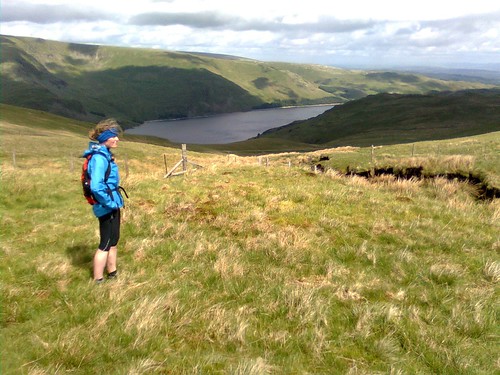
There were very few behind us (only two runners I think) as we set out on the first ring - a trip out up Wet Sleddale and Mosedale to Branstree and Selside Pike, then down Swindale to Rosgill and back past Shap Abbey to Shap itself. We set a decent rapid walking pace out to the River Lowther and up into Wet Sleddale, climbing above the reservoir with Zoe looking very much the part and doing a lot of the nav work.

Image0092
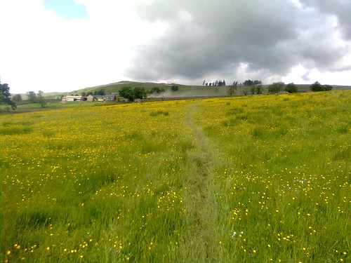
Across a meadow to the farm in Wet Sleddale - they were liming the field beyond the farm

Image0093
Zoe, looking the part and enjoying it (at Mile 4!)

From road above the reservoir we took a track zigzagging past Sleddale Hall which is abandoned but looks like it may be under restoration. Another 3km took us up to the watershed between Wet Sleddale and Mosedale, where we consulted the map and compass for a few moments to check that the indistinct grass path would lead us down to the bridge in Mosedale. We ran the descent and jogged across the bridge and up to Mosedale Cottage (which has been refurbished fairly recently) where we overtook the first walkers from the main start, a family group of five doing just the first ring.

Image0094
Just before Mosedale Cottage (12km)
The climb to Branstree was relatively straightforward, up a stream to a wall and then along the ridge to the top. Except that I got too near the stream at one point and left my right leg in the most gloopy hole full of brown slop imaginable. Anyway we caught another couple of walkers up at the top and from then on it would be a fairly steady stream for the remainder of the first loop.

We headed along the fenceline to Selside Pike where we caught another few walkers up at the top and from then on it would be a fairly steady stream for the remainder of the first loop.

Image0095
View to Haweswater from between Branstree and Selside Pike
Image0096
Summit of Selside Pike (17km)
Image0097
Pair of walkers near the summit of Selside Pike
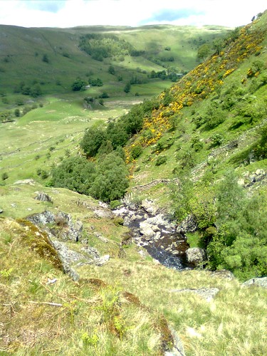
From Selside Pike we dropped down across Hobgrumble Gill to a short climb onto Nabs Moor, before descending easy slopes to the top of Forces Falls, the point at which Mosedale runs down into Swindale. The descent from here to the valley of Swindale was beautiful, down a rocky ridge adjacent to a series of waterfalls and plunge pools.

Image0100
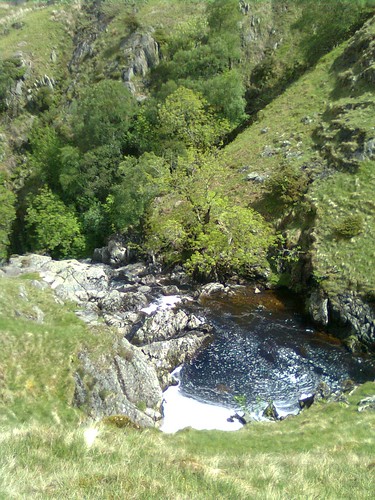
Beautiful plunge pools on Swindale Beck

Image0102
View down into Swindale

Image0103
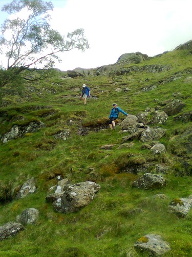
Technical descending into Swindale

Image0104
Zoe running the final section of the descent
A short run along the edge of the beck through moraine led to a lane which turned into the road and led to the first checkpoint at Truss Gap. In a barn by the road were a couple of the Cumbria LDWA stalwarts, logging time, clipping tallies and dispensing superb baked goods. Two currant slices and a piece of cherry cake later and we were on our way up a gentle traversing path to climb above Swindale, passing a farm at Rayside and then recrossing Swindale Beck before joining the road over the River Lowther into Rosgill.

We snuck through a footpath next to an almost abandoned cottage to join a lovely grassy path which ran along the break of the escarpment above the River Lowther, passing close by Shap Abbey to reach the village of Keld, and then followed anothe path through fields past the brilliantly-named "Goggleby Stone" back to Shap and the event centre.

Shap Abbey
Having walked and jogged the first 18 miles and 2,600' of climbing in a bit under 5 hours, we took 25 minutes at the checkpoint to regroup. I redressed my foot which was rubbing quite badly, filled our bottle, swapped the maps and route description and we had a cup of tea.

Duly refreshed we set out on the steady eastward climb which would set us on the way around the second "rivers" ring.  (22 min to start of Zoe's track)

This took us up to Hardendale and over Iron Hill into Reagill and then down to eet the River Livennet at Barnskew. I'd never heard of the Livennet before but it drains quite a significant area north of Crosby Rasenworth Fell between the Lowther and the Lune, and the section we followed was a lovey reach of river. About a third of the way along the river (at about the 8 mile point on the leg) we came to the promised water point...

Image0106
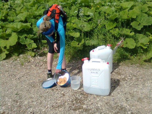
World's most primitive checkpoint - good selection of broken digestives in there, but Zoe
grabbed the only malted milk before I had chance to...
I really liked the minimalist and simplistic approach to resupply here. The next section of the route was really pretty, criss-crossing the River Livennet over a series of small bridges.

Image0107
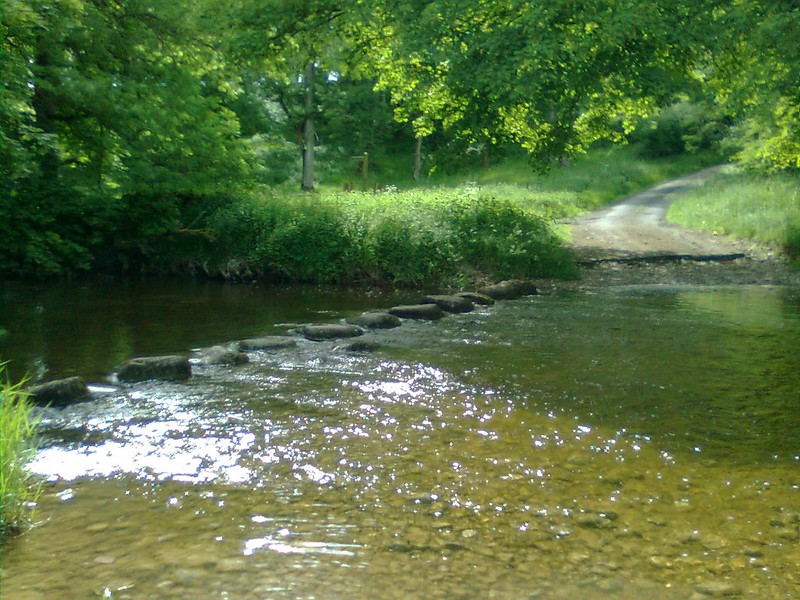
Stepping stones across the Livennet, about the only place we didn't cross!
Eventually we left the banks of the Livennet and passed through the villages of King's Meaburn and Morland before skirting Cliburn (which looked quite pretty on the descent to the bridge). Leaving the second field after Cliburn there was a big boggy patch (one of very few) and Zoe slipped and saved herself from falling using the stile, which unfortunately was wrapped in barbed wire. We stopped for running repairs with the world's tiniest plaster (the only one left in my first aid kit - must replace them when I use them) and some Micropore. Duly patched up we finished this field section, came out via a farm land onto a road, and then had a real draggy section of a bit over 2km to the checkpoint at Great Strickland.

The checkpoint was in the Strickland Arms (well in the back garden actually). This was at 53.5km: I'm quite glad I didn't realise that at the time, it seemed like we'd already gone a fair way - we reached the checkpoint at 18:16 (09:22 elapsed). We stopped for maybe ten minutes while I patched up my feet again, and partook of the excellent selection of savoury snacks (including mini-pasties - a very welcome first time I've seen these on an event). Just as we were getting ready to leave it started to rain, so we cagged up there and then - I thought it might last a while!

Another 2km of roads led us down and across the River Leith (second of the three rivers this Ring is named for) and on to another of those places where we made a minor navigational error, using the wrong "gate by pylon". Zoe and I had passed a couple of groups of walkers on the road and with a bit of shouted communication we soon sorted it out and found the key bridge over the West Coast Main Line. A zigzag under the motorway led us up to the A6 at Hackthorpe. It was raining on and off, and we wanted to get as far as we could back towards Shap before it set in properly, so I avoided the temptation of another pub, and we headed on uphill through a nature reserve-type area, trending left on unmarked paths through deep undergrowth in the hope that this would bring us out in the right place. We actually came out 200m NE of the gate we'd hoped to be at, but fortunately there was another track through the nettles.

We passed through a gate and a short section of woodland into Lowther deer park. As we came down Round Hill towards Lord Greening's Plantation we could see a big herd of deer off to our left. They seemed fairly unconcerned about the string of walkers spread out over their grazing land. A bit of up and down and a long section with woods on our right led us out of the deer park and across fields to High Knipe. Zoe and I were making good progress, mostly powerhiking but with some running too, and we passed quite a lot of participants on this section.

Shortly after High Knipe Farm, on a section of road, we came to the second unmanned checkpoint on this Ring, at 62km. Again there were biscuits and water. We must have overtaken a good few folks because this time there was a reasonable choice of biscuits left including a chocolate chip cookie!
 
From here we dropped down rapidly to the River Lowther, which we crossed on a fairly bouncy suspension footbridge. We turned and ran upstream with the river on out left for a couple of kilometers to reach Bampton Grange, where we crossed the river and heded along the other side to reach Rosgill - the only point we'd pass twice during the Three Rings.

We passed the cottage we'd been past on the first Ring, then made a second, more serious navigational error, turning left too soon (following someone else who'd done the same thing - never assume the folk in front know where they're going). We sorted it out after a couple of minutes with the map and hopping over two barbed wire fences, continuing uphill towards Shap in increasingly heavy rain. By the top of the next hill it was pouring, and we could see the chap who'd gone too far left was now away over to the right of the route in a field containing the almost aptly-named Thunder Stone. We shouted him, but I don't think he could hear over the rain.

Crossing the lane we made a diagonal beeline across three fields of very wet long pasture which finished off soaking my feet and made sure the repair work I'd done at Strickland would need re-doing at Shap. We followed the Ring One route into Shap from the end of the fields and reached the Hall (70km) at 21:12 (12:18 elapsed time). There weren't too many in the hall this time and we realised quite a few of those there we packing up to go home after two Rings.

We took way too long at the checkpoint really, but I re-dressed my feet from scratch and put new socks and fresh insoles in my shoes to try to keep feet dry for a while. We both ate some proper food too, and changes into a totally fresh set of (dry) clothes. I changed cag from my racing jacket which isn't really ideal for long trips into my mountain jacket which is much better for nights out. We left the hall at dusk, I guess just before 22:00 as the fastest runners were starting to come back in off Ring 3. I was quite pleased to see we hadn't actually been lapped! But I kept remembering the aim here was to ensure Zoe finished and qualified for the 2014 Hundred, and to do so I just needed to keep myself in one piece. So we would be doing relatively little running on the night section!

We started, still in heavy rain, up across the railway and along a stony lane into fields, climbing diagonally to reach a footbridge over the M6. From there we walked through rough fields along the east side of the motorway before I made yet another navigational error and this time decided not to follow the pair in front, but to climb left. Unfortunately it was a hundred yards too soon and we had to drop back down and try again in the next field.

At the top of this climb we crossed the haul road for Hardendale Quarry then followed another haul road down to the hamlet of Oddendale. By now we'd caught up the pair in front, Tony Natale and Andy Carpenter. We passed them on the next section, a long track on a green road gently uphill towards an enclosure called "Potrigg". Just after this we were supposed to fork left, and did so a little too late in the very last vestiges of twilight. Fortunately Tony and Andy shouted us. We then found and followed a nice line across Crosby Ravensworth Fell to reach a critical wall corner. From here the navigation would be straightforward, keeping a wall on our left for 2km as we made a crcuit of the headwaters of the River Livennet.

We then crossed another kilometer of open ground to meet the Orton - Crosby Rasenworth road. I think we were supposed to go straight over here and up past a plantation between this road and the Appleby to Orton road, but we missed it and ended up following the first road uphill to the junction of the two. By now Tony and Andy were in front of us again, and we duly caught and passed them again on the climb to Beacon Hill. We worked together to identify the gate to leave the fell through and dropped down across some fairly indistinct ground into the first of the limestone pavement landscape to try to find the entrance to Great Asby Scar National Nature Reserve.

Once in the reserve we followed a track which curved left after a little while. I'd noted we didn't want to go left when I went through the maps before the event, but went left anyway for some reason. Again Tony and Andy came to the rescue. The rest of the route through the Nature Reserve was straightforward though, and we were fairly soon out onto a farm track which became the road leading to the final manned checkpoint of the event, at Great Asby (86km, arrived at 01:22, time elapsed 16:30).

The checkpoint was brilliant, a gazebo with side panels (is that a tent then?) and a gas heater in the corner of a field. The malt loaf and chees was even better. We stopped ten minutes, and then headed out, passing several other participants on the road down towards Great Asby. These would be the last folks we'd overtake except for Tony and Andy (again!). We hiked up a long farm lane past the entrance to Halligill Farm, and promptly I got confused again on another tricky section. I set a bearing to follow the line of the path marked on the OS, and we ended up in the middle of nowhere at a brand new fence. A hunt around revealed no sign of any stiles. Zoe caught sight of Tony and Andy's headtorches down to the left, and we now realised they'd done the route before, so we made a beeline for them, and caught them up once more in the vivinity of Gaythorne Hall.

We walked together for a while up to a road junction on Coalpit Hill (wonder what they used to do there?) and then down the byway to Bank Head Farm, before we jogged on ahead down into a very sleepy Crosby Ravensworth village. It was now about 3am and just starting to get light as we trotted through the village. The next section was a long slog up a pretty little valley, first on a lane, then on green tracks through fields. We could see Tony and Andy's headtorches some way behind. My torch was off now except to look at the instructions. Zoe was very tired on this section, not so much physically, more just in terms of feeling she needed to sleep. I couldn't persuade her to eat anything or take a ProPlus either. Anyway she rallied as we reached Oddendale. It was her only bad patch really.

From here on back it was a case (largely) of following the outward route, along the quarry road and then around Hardendale Nab, with a slightly different route taking us north of the house at The Nab and down through fields to the motorway bridge. There were some pretty inquisitive horses in the first field and Zoe was a bit worried by them, so we jogged down to the motorway. After the bridge the last two kilometres back into Shap were fairly plain sailing. We arrived back at the Hall at 04:29, 19 hours and 32 minutes after we had started. I have the total distance from GPS as 103.3km.

The hall was almost deserted - there had only been one finisher since 3am. We were checked in and very well looked after with hot quiche making a really satisfacory breakfast! Tony and Andy came in three minutes after us and we were finally able to have a decent chat, having swapped places several times en route. After a while we gathered our stuff together and headed back to the Shap Wells Hotel to get some sleep.

I was pretty satsfied with this event. There wasn't any way our time was likely to set the world on fire, me three weeks after a hundred miler and with sore feet, and Zoe on her first event over 50km. But we finished joint 35th out of 89 starters and 55 finishers, and we achieved the objective of getting Zoe qualified for the Hundred. Not only that but we'd had a great and very varied big day's running and walking and really enjoyed it together.